TL;DR: The Amalfi Coast has some of the finest coastal hiking in southern Europe. The Path of the Gods (Sentiero degli Dei) from Bomerano to Nocelle is the signature route, 7.8 km, moderate, with views across the Tyrrhenian Sea and the coastal cliffs that make the coast famous. Go in April–June or September–October. Wear proper hiking footwear. Start early.
Most visitors to the Amalfi Coast see it from below: the ferry deck, the clifftop road, or the terrace of a restaurant in Positano looking out at the same view that has appeared on every Italian travel poster since colour printing was invented. The view from below is genuinely beautiful. But the view from above, from the limestone ridgeline that runs along the length of the Lattari Mountains, looking down at the towns clinging to the cliffs and the sea extending to the horizon, is something else entirely.
The coast has a network of ancient footpaths that predate the cliff road by centuries. These were the routes the villagers used to move between settlements before the Strada Statale 163, the Amalfitana, was cut into the rock in 1853. The paths are still there, maintained now by the CAI (Club Alpino Italiano) and increasingly well-marked for walkers. The most famous is the Path of the Gods. But it is not the only one, and knowing the alternatives separates the hikers who have done some research from those who have simply followed the guidebook’s first suggestion.
The Path of the Gods (Sentiero degli Dei)
The Sentiero degli Dei runs along the high ridge above the coast, roughly from Bomerano (a hamlet of Agerola, on the plateau above the coast) to Nocelle (a tiny village above Positano). The name, Path of the Gods, is attributed to the Greek gods who were said to have used the route to watch the Sirens who inhabited the sea below. The mythological explanation is probably post-hoc; the practical explanation is that the views from the trail look like something a reasonable person might describe as divine.
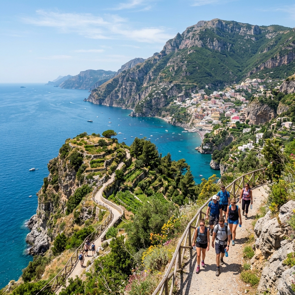
The Route
Standard direction: Bomerano to Nocelle (recommended). The trail loses approximately 700m of altitude over 7.8 km, making it net downhill when walked in this direction. The Nocelle end is more dramatic, the descent toward Positano, with the town spread below and the sea filling the horizon, is one of the finer conclusions to a hike in southern Italy.
Reverse direction (Nocelle to Bomerano): Possible, but the significant uphill at the start (roughly 300m of climbing in the first 2 km) makes this harder and removes the satisfaction of arrival.
What You’ll See
The trail passes through terraced agricultural land in the early stages: the hillside above Bomerano is still worked, and the dry-stone terracing that holds the lemon groves and the kitchen gardens in place on slopes that would otherwise be too steep to farm dates back, in places, to Arab and Norman land management practices from the 10th century. The terracing is one of the most quietly impressive things on the trail, the sheer labour of building these walls, level by level, on near-vertical ground, over generations.
The middle section opens onto the high ridge, where the path becomes rocky and exposed and the views extend across the full width of the coastline: Positano to the west, the island of Capri visible on clear days, the Gulf of Salerno opening to the south. The coastal towns below look implausibly small, tucked into notches in the cliff face. The scale is better understood from up here than from any point on the main road.
The final descent into Nocelle passes through pine and macchia (the dense aromatic scrub of rosemary, myrtle, and cistus that covers the uncultivated hillsides), arriving at a small square with a bar that serves espresso and cold water at exactly the right moment.
Logistics
Getting to Bomerano: SITA buses run from Amalfi approximately hourly (journey time 55 minutes, €2.50 with a Unico Costiera ticket). Check the SITA timetable before you go, services reduce outside high season and the last bus back from Amalfi can be earlier than you expect.
From Nocelle: A flight of approximately 1,900 steps (the Sentiero Positano–Nocelle) descends to Positano in 30–45 minutes. The steps are paved, with handrails in the steeper sections, and are manageable if your knees are willing. Alternatively, a local minibus connects Nocelle to the main Positano bus stop on the Amalfitana.
What to bring: Water (at least 2 litres per person, there are no reliable water sources on the trail), sun protection, a light layer for the ridgeline where wind can be significant even in summer, and hiking boots or trail runners with grip.
The Valle delle Ferriere
The Valle delle Ferriere is the least known of the main Amalfi Coast hikes and, in some respects, the most interesting. The trail begins at the eastern edge of Amalfi town, past the paper mills (the valley was once a centre of paper production, hence ferriere, the old mills), and climbs into a narrow gorge that acts as a nature reserve.
The valley contains one of the last populations of Woodwardia radicans, a large chain fern that has survived largely unchanged since the Tertiary period, a botanical relic of the climate that existed in southern Italy before the last ice age. Walking into the upper valley is a gradual transition from the cultivated terraces of the lower coast, lemon groves, chestnut trees, into something wilder and denser, with the fern fronds overhanging the path in the highest section and the sound of the stream below replacing the sound of traffic.
Trail details: 4.5 km return from Amalfi town; 2–3 hours including time to explore. Rated easy to moderate. The path is shaded for most of its length, making it one of the few walks on the coast that is acceptable in July and August (though still not ideal).
Practical note: The upper section of the valley is sometimes closed for maintenance or after heavy rain. Check with the Amalfi tourist office before setting out.
The Path of Lemons (Sentiero dei Limoni)
Between Maiori and Minori, a path runs through the lemon groves that cover the terraced hillsides above the two towns. The walk is 3.5 km one way, taking around 1 hour 30 minutes at an easy pace, with a modest 200m of ascent. It is the most accessible of the three main hikes, shorter, lower, and navigable in ordinary walking shoes if the ground is dry.
The lemon groves on the Amalfi Coast produce the sfusato amalfitano, a long, tapered variety with a thick, fragrant rind that is the basis for the coast’s famous limoncello. The groves are still worked by family producers who sell their fruit to the local limoncello distilleries. Walking through them in April and May, when the blossom is out, is one of the coast’s finest sensory experiences: the smell is intense, clean, slightly sweet.
Start point: The lower trailhead is in Maiori, signposted from the beach promenade. The upper trailhead connects to Minori. Both towns are served by SITA buses from Amalfi.
What to Know Before You Go
Footwear
The single most important preparation decision. The Amalfi Coast trails are rocky, uneven, and in places significantly exposed. Hiking boots with ankle support are the correct choice for the Path of the Gods; trail runners work well for the Valle delle Ferriere and the Path of Lemons. Sandals, flip-flops, and flat canvas shoes are not suitable for any of these trails, and the coast’s mountain rescue service (Soccorso Alpino) responds regularly to walkers who underestimated this.
Start Early
In summer (June to September), temperatures on exposed trails reach 30°C by 10am. The standard advice, start by 7am, finish by noon, is correct. The light in early morning is also better for photography, and the trails are emptier.
Transport Planning
The Amalfi Coast road (the Amalfitana) is served by SITA buses connecting all the main towns. The Unico Costiera integrated ticket (€8 for one day, €12 for three days) covers all bus routes on the coast and is essential if you are moving between trailheads. Traffic on the Amalfitana is extreme in July and August; buses are slower than the timetable suggests. Allow extra time.
Accommodation
Positano, Ravello, and Praiano all make reasonable bases for hiking. Ravello is the least touristed of the three, sits at elevation (365m), and is within walking distance of several trail connections. Praiano, between Positano and Amalfi, is significantly cheaper than its neighbours and has direct access to the coastal paths without the Positano price premium.
After the Hike
The food on the Amalfi Coast is unapologetically simple and mostly excellent: fresh pasta with seafood, grilled fish from the local catch, sfusato lemon in everything (pasta al limone, lemon granita, limoncello), and the mozzarella di bufala that comes from the plains around Paestum, 50 km south. After a long walk, a plate of spaghetti alle vongole at a waterfront restaurant in Amalfi or Minori, with a carafe of cold white wine and the sun dropping toward the water, represents one of the better post-hike meals available anywhere in southern Europe.
FAQ
How difficult is the Path of the Gods hike? The Path of the Gods is rated moderate. The standard Bomerano-to-Nocelle route is approximately 7.8 km one way with around 300m of ascent and 700m of descent, taking 3–4 hours at a steady pace. The terrain is rocky and uneven in places. Hiking boots with ankle support are strongly recommended.
When is the best time to hike the Amalfi Coast? April, May, and early June are ideal: moderate temperatures, wildflowers, and manageable crowds. September and October are excellent alternatives. Avoid July and August for hiking, temperatures reach 32–36°C on exposed trails.
Do I need a guide for the Path of the Gods? A guide is not required, the trail is well-marked with red and white CAI blazes. However, a guide adds value if you want context on the local flora and the agricultural history of the terracing. The Cooperativa Trekking Amalfi offers guided walks in English.
How do I get to the start of the Path of the Gods? The standard starting point is Bomerano, accessible by SITA bus from Amalfi (approximately 1 hour, €2.50). The trail ends at Nocelle, above Positano; from Nocelle, a staircase descends to Positano or a local bus connects to the main road.
What is the Valle delle Ferriere trail like? The Valle delle Ferriere is a 4.5 km trail from Amalfi town into a steep valley that contains ancient fern species surviving since before the last ice age. It is rated easy to moderate and takes 2–3 hours return. The valley stays cool even in summer, making it one of the few hikes on the coast that is manageable in July.